A site plan drawing app for iPhone and iPad
Field CAD is a site plan drawing app that does floor plans too. A walk around the house becomes a drawing to scale, and that one drawing feeds the takeoff, the proposal, the inspection report and the customer's 3D view.
Drawing hints that keep the walls square
While you draw, a wall lines up with any corner on screen, matches the length of its parallel side and shows a square-corner mark. Type the real length on the keypad and keep walking.
- Drawing hints
Walls align with corners, match parallel lengths, snap parallel and show square corners while you draw; lengths typed on a keypad.
- Plan and aerial underlays
Trace over a plan PDF or an aerial picture with Set scale.

Scan the whole house with LiDAR
On an iPhone Pro or iPad Pro, walk the house in one scan, room by room. Rooms that came out on top of each other are shown in red so you can drag them into place before they reach the drawing.
- LiDAR whole-house scan
One scan for the whole house, Next room between rooms, Next floor upstairs; overlapping rooms shown in red to place by hand; corners squared within 3 degrees.
Needs an iPhone Pro or iPad Pro with LiDAR and the installed app.
Start from the address
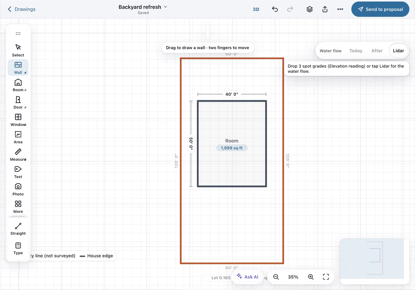
Open a new drawing on a job with an address and the satellite background is already there, from public imagery with its source and date. In supported Texas counties the lot line and the house footprint are drawn for you in one step.
- Satellite background from public imagery
TxGIO StratMap in Texas (3 to 6 inch), USDA NAIP elsewhere in the US, each picture with its source and capture date. No Google imagery.
- Lot and footprint from the address
A new drawing draws the parcel line and the house footprint in one step with 0 taps, plus lot acres and yard square feet, each with its source and "not a survey".
In supported Texas counties: Hays, Bexar, Travis, Williamson and Comal. Footprints from FEMA USA Structures.
Showing the drawing in 3D
One tap shows the drawing in 3D, live from the plan. Floor readings become a heat map in plain words, and the customer gets a 3D link that expires when you want it to.
- 3D view and customer 3D link
One tap shows the drawing in 3D, live from 2D; a customer 3D link that expires and can be revoked; AR / GLB export.
- Floor heat map and profile
Three or more elevation readings color the floor (red sinking, amber settling, green level) and a floor profile draws the levels along a line.
- 360 tours
360 photos and videos pinned on the plan with a direction arrow, hotspots room to room, a mini-map, and customer tour links that expire.
- Live drawing collaboration Beta
Two people on one drawing at once, with offline edits merged and history kept.


A Field CAD plan in 3D
A Field CAD plan with its rooms and their square footage opens in the editor. One tap on 3D builds the model from the same drawing, and a drag turns it around.
Also see the room scanning app page.
How a drawing becomes a signed proposal
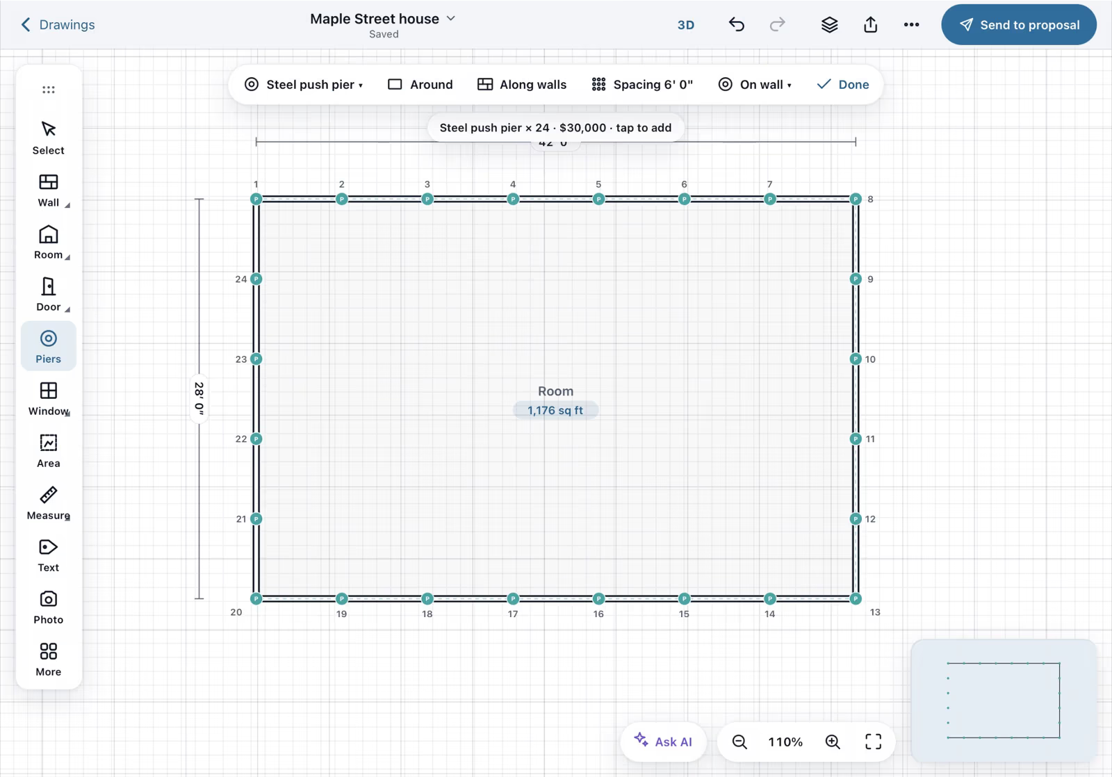
Draw each wall with a finger and type its length on the keypad.

With the outline closed at 1,176 sq ft, Around spaces 24 steel push piers 6 feet apart and shows the $30,000 total before you place them.

The takeoff goes into the proposal as a repair estimate with 24 piers at $1,250 each, the permit and the engineer's letter, and a 50 percent deposit.

The homeowner signs with a finger on their own phone and accepts the proposal.
Recorded in FollowStack with demo data. Names, addresses and numbers are made up.
See it in use
A call turned into a signed proposal
The missed call gets a text, the visit is booked near the address, and the proposal is signed on site.
See the stepsField CAD drawings on site
Draw the house with typed lengths, measure the roof, and price it from the drawing.
See the stepsReal estate agents
A LiDAR floor plan, 360 tours, listing-prep notes and showings booked for you.
See the steps
User guides for field CAD
- Draw a house plan in Field CADOutside walls with real lengths, rooms, doors and windows. The takeoff adds up as you draw.8 min
- Start a drawing from the addressThe lot line, the house footprint and a satellite picture from public data, each with its source.3 min
- Show the drawing in 3D and share itOne tap shows the plan in 3D, live from 2D. Send the customer a 3D link you can turn off.2 min
- Scan the whole house with LiDAROne scan for the whole house on an iPhone or iPad Pro with LiDAR. Next room between rooms, Next floor upstairs.6 min
- Turn a plan picture into a drawingA screenshot from ArcSite, a scan or a photo of a sketch, put to scale and traced or redrawn by the AI.5 min
- Place piers around the houseYour own pier products, every N feet around the outline or in a row on a beam line, in a few taps.5 min
- Elevation readings and the heat mapType each reading on the plan. Three or more color the floor and draw a floor profile.4 min
- Make a 360 tour360 photos pinned on the plan with a direction arrow, hotspots room to room, and a link for the customer.4 min
Used by these trades
- Foundation repair
- Basement waterproofing
- Structural and civil engineers
- Concrete and flatwork
- Siding, windows and doors
- Painting
- Landscaping
- Hardscape, decks and patios
- Fencing
- Sod and artificial turf
- Asphalt, paving and sealcoating
- Electrical and lighting
- Security systems
- Low voltage, telecom and building controls
- Remodeling and home improvement
- Flooring
- Pressure washing and exterior cleaning
- Real estate agents
- Architects and designers
- Drywall and insulation
- Masonry
Questions
Do I need LiDAR?
No. You can draw any plan by hand on any iPhone, iPad or computer. LiDAR scanning needs an iPhone Pro or iPad Pro with a LiDAR sensor.
Where does the satellite picture come from?
It comes from public imagery. Texas StratMap from TxGIO is used where it covers the job and USDA NAIP elsewhere in the US. The picture shows its source and capture date.
See FollowStack on one of your own jobs
Bring an address you're bidding this week. We'll draw it and price it with you, live on the call.